


Newtownards
NEWTOWNARDS: Civil airport later military aerodrome, later still… civil aerodrome. (Often known simply as ARDS or even ARDS AIRPORT for some reason)
Military users: WW2: RAF
231 Sqdn (Westland Lysanders & Curtiss P-40 Tomahawks)
Operated by: 1930s: Airwork
Miles Aircraft factory 1946-48?
1960s to 2000s: Ulster Flying Club (1961) Ltd
British airline users: Pre 1940: Blackpool & West Coast Air Services, Hillman’s Airways, Railway Air Services, United Airways
Post WW2: Manx Airlines, Silver City
Flying club/school: Ulster Flying Club (1961-)
1959 ‘snapshot’. Tipsy Flying Group, Ulster Flying Club
Helicopter ops: 2000s: Helicopter Training and Hire
Maintenance: 2001: Kenboag
SOME LOVELY PICTURES
These four lovely pictures from postcards were kindly sent by Mike Charlton who has an amazing collection. See, www.aviationpostcard.co.uk
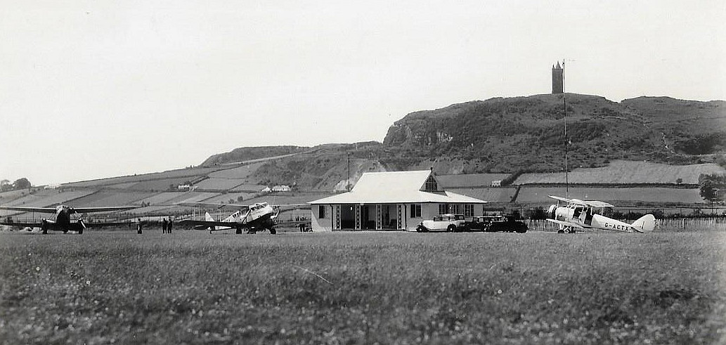
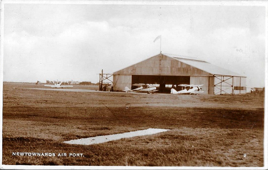
First picture: This seems easy enough to date because the Avro 638 Club Cadet G-ACTX was registered to - take a deep breath - Charles Stewart Henry Vane-Tempest-Stewart, the Most Hon. The Marquess of Londonderry, from the 10th of November 1938 until the 12th of May 1939. It then went to Southend-on-Sea Flying Services from the 16th May 1939 until the 1st December 1946. So, was it impressed for military service during WW2? To the left is a de Havilland DH84 Dragon, and left again, a DH89A Dragon Rapide. But operated by which airline(s)?
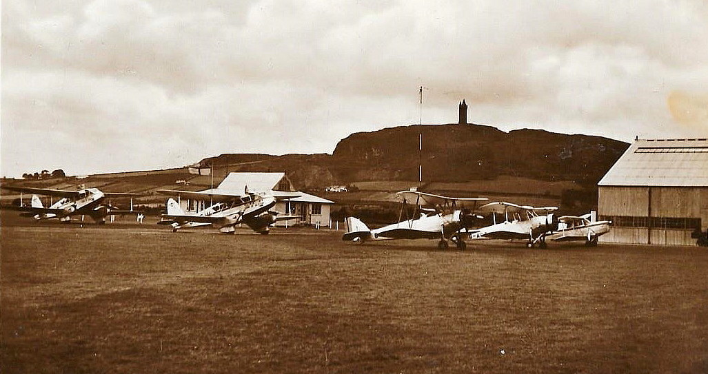
Second picture: This is captioned "Ard's Airport, Newtownards". From left to right are two de Havilland DH89A Dragon Rapides - but from whose airline? Then, I feel fairly certain (?), are a brace of Avro 638 Club Cadets. Last but not least a de Havilland DH87B Hornet Moth.
I have captioned this picture as being in the late 1930s, but would this be correct? It could, I think, easily be post WW2. Can anybody kindly offer advice?
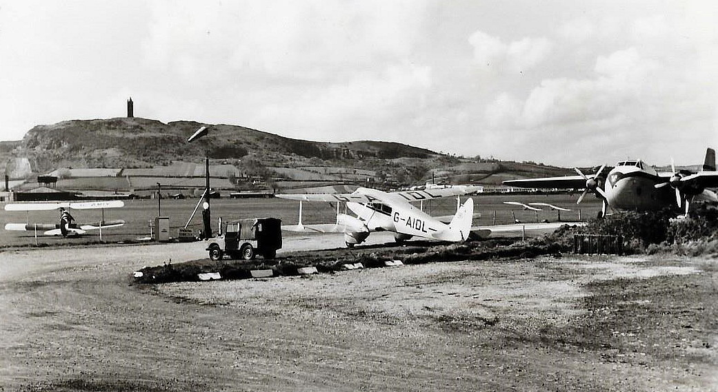
Third picture. What a corker; captioned as "Silver City air service". With a Silver City Bristol 170 Freighter in view. Probably a Wayfarer passenger type rather than a car transporter. As for the DH89A Dragon Rapide G-AIDL I have given up trying to work out what it was doing here. Almost certainly not involved in commercial airline work?
Fourth picture: Clearly a DH87B Hornet Moth in the centre, flanked (possibly?) by a brace of Avro 638 Club Cadets.
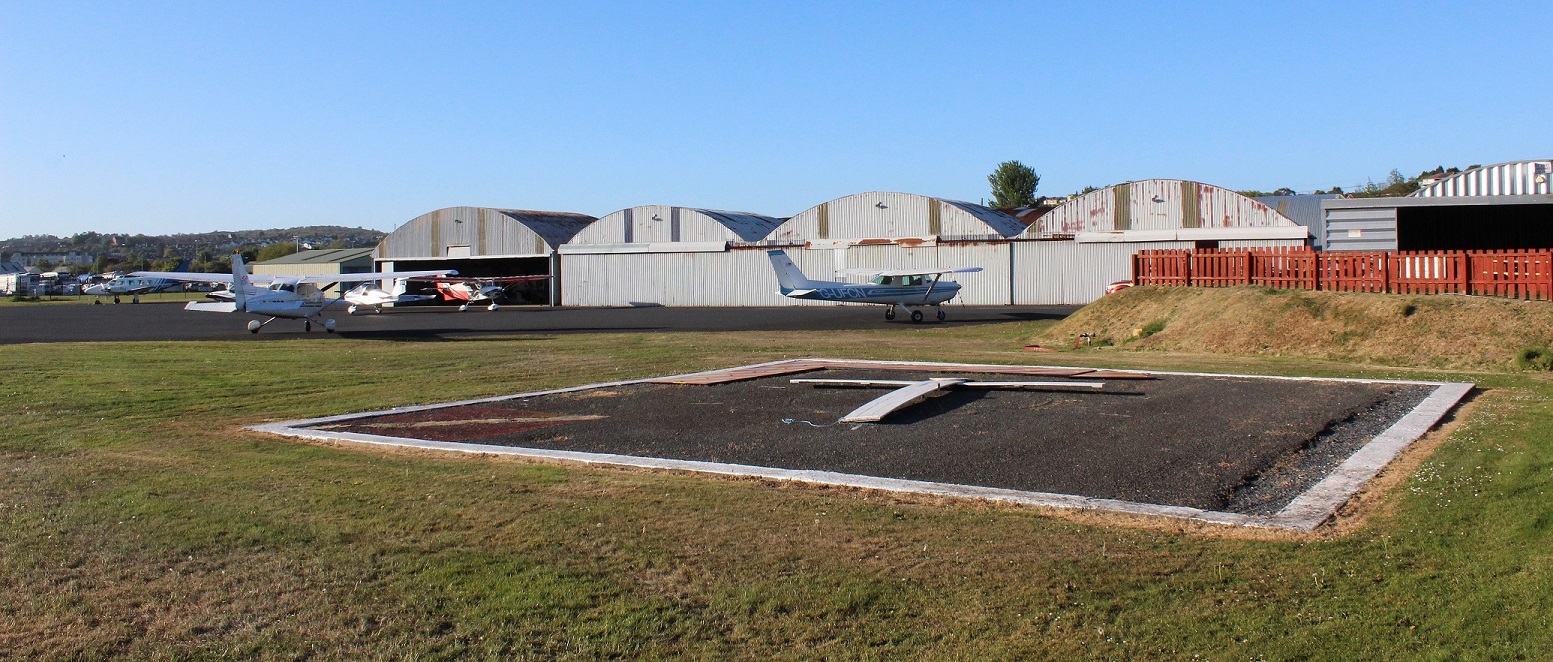
A FLEETING EVENING VISIT IN 2017
Location: W of A20, Approx. 6nm ESE of Belfast City airport, 9nm E of Belfast
Period of operation: Civil: 1934 to ? Military: ? to 1945 Civil: 1961 (?) to today?
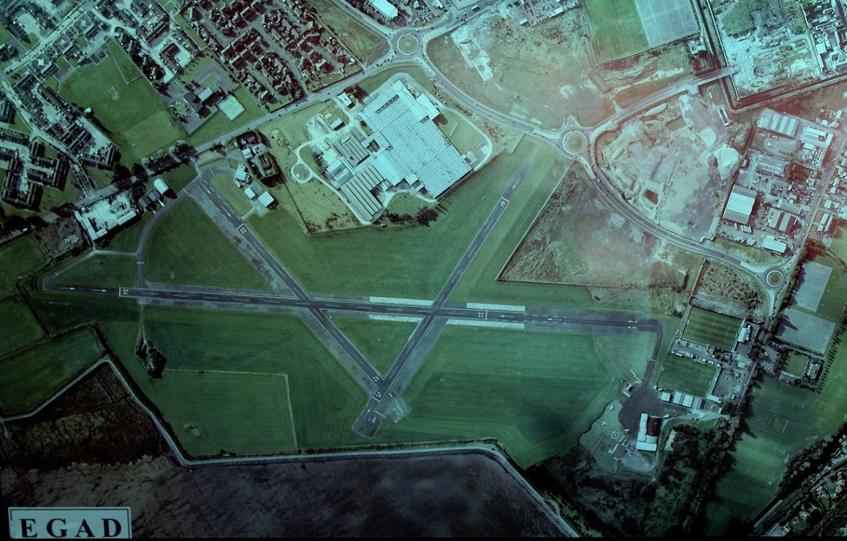
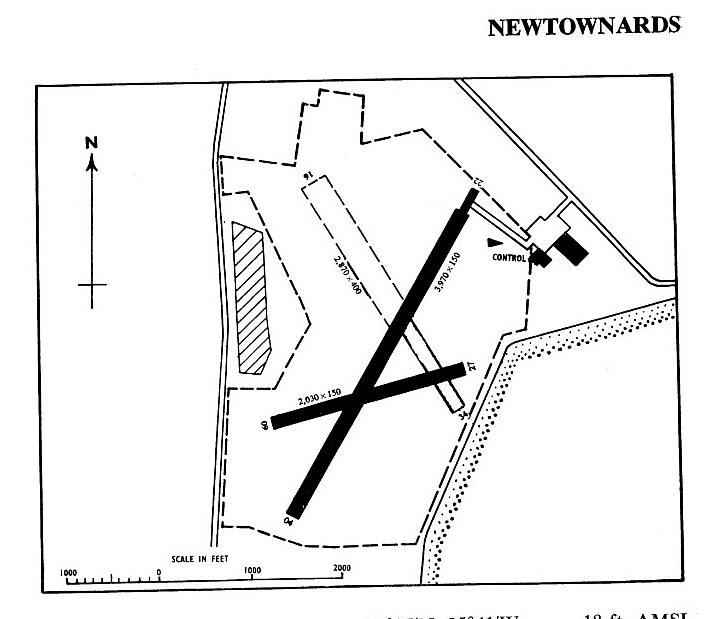
Runways: 1934: It appears the aerodrome area was initially 60 acres.
NE/SW 576 grass N/S 549 grass SE/NW 549 grass
Note: Now here are good grounds for confusion. The runways are listed according to one major source, ‘MILITARY AIRFIELDS in the British Isles 1939-1945 (Omnibus Edition) by Steve Willis and Barry Holliss, reckoned to be the ‘bible’ regarding WW2 aerodromes as being, in 1944:
09/27 335x503. In concrete and tarmac with grass extensions. As were 04/22 1177x46 hard/grass and 16/34 610 hard/grass
The problem is that a very basic map shows three runways one being very short but the notes say that runway 09/27 is 333x503. A big and very obvious mistake! The short runway on the map I have seen runs pretty much north/south…not east west! According to the ludicrous dimensions given the width obviously far exceeds the length so why didn’t somebody notice this? I also expect to make some mistakes along the way, (despite having the best intentions), but I do hope I haven’t made a cock-up as big as this without noticing it.
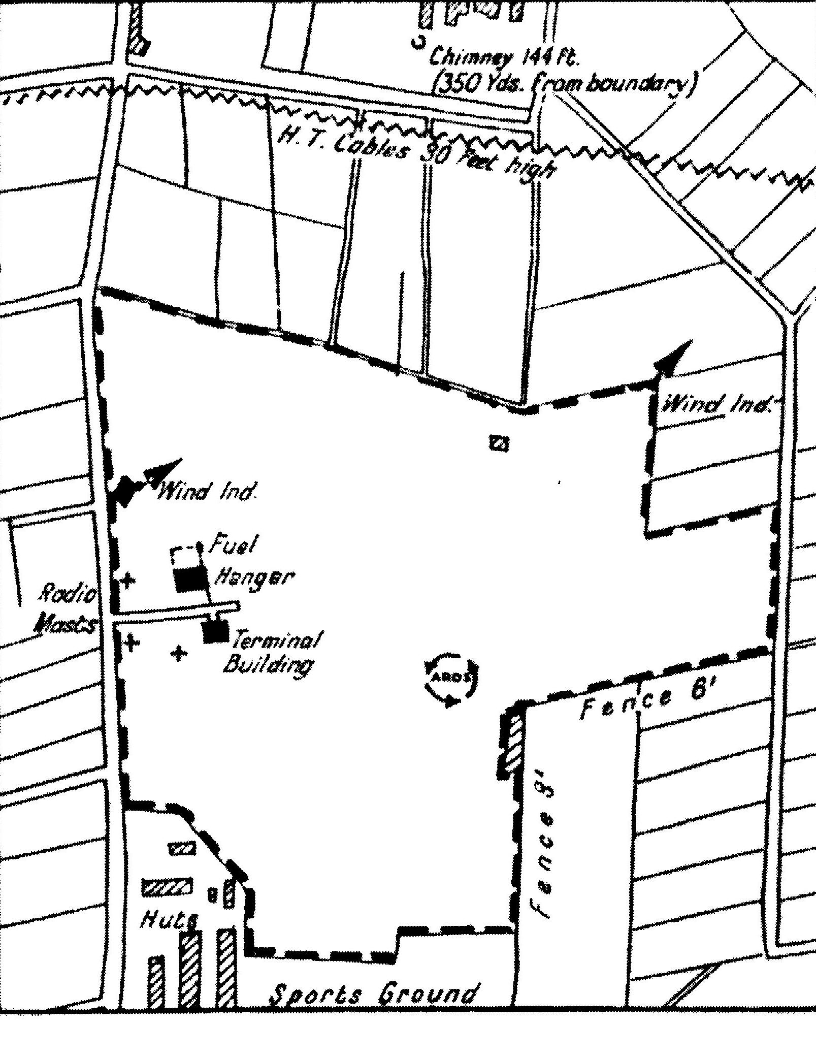
Note: These maps are reproduced with the kind permission of Pooleys Flight Equipment Ltd. Copyright Robert Pooley 2014.
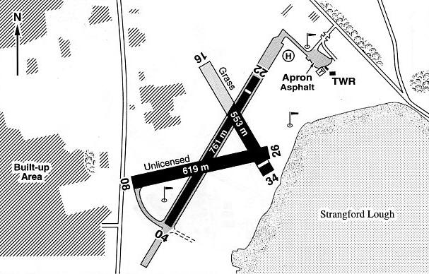
1965: 04/22 1210x46 hard 09/27 619x46 hard 16/34 875 Concrete and grass
Note: It appears that the concrete runway on runway 16/34 was 343x46, and the grass area 875x122, most of the NW end.
1990: 04/22 759x25 hard 09/27 619x46 hard 16/34 553x46 grass
(At this time it was advised that runway 16/34 had a paved 345x45 strip at the SE end)
2000: 04/22 761x25 hard 08/26 619x46 hard 16/34 553x46 hard/grass
2001: 04/22 794x18 hard but with 04 having a 150x18 grass starter extension and 22 a 80x18 grass starter extension. In other words at 1024 metres in total length, pretty close to the WW2 length.
08/26 566x18 hard/grass
Runway 16/34 is very unusual in that it is basically divided into two halves along it’s length. I wonder what the reason for this is? My guess is that those who know they can land short can save time and taxy up runway 04/22 to the club house and facilities. At the NW or 16 end the NE side of the runway is given as 310x25 hard. The main or SW side is 644x18 hard
NOTES: This airfield/airport opened on 31st August 1934. Some records seem to indicate it opened as a military airfield but I doubt this - is this doubt justified? By early 2013 I was quite convinced that when this airport opened in 1934 it was only for civil use. In his book The Triple Alliance Neville Doyle gives this account: “The opening ceremony of the new aerodrome at Newtownards, 9 miles E of Belfast, took place at 2.30 pm on Friday, August 31st 1934 following a luncheon given by its owner, Lord Londonderry. There was an air display in the afternoon and both Hillman’s and BWCAS transferred immediately from Aldergrove. Railway Air Services, on the other hand did not transfer across until the enlargement of the airfield from 60 acres to 100 acres was completed in May 1936”.
This said, there is evidence that Hillman’s Airways had given up trying to compete with Railway Air Services, on the Belfast route at least, as soon as the end of September 1934. Just one month after moving their operation from ALDERGROVE. But then it seems, Hillman’s Airways were awarded the GPO contract to carry mail, the inaugural service being on the 1st December 1934 with an extension to Glasgow (RENFREW).
None of the above really matters to me when researching this Guide but I do find it fascinating that every so often there is so much doubt about quite straightforward aspects of the history concerning many well known aerodromes. And - that so many flight guides publish different and often contradictory information. The main point I am concerned with is of course, obtaining reasonable proof the place actually existed
We'd love to hear from you, so please scroll down to leave a comment!
Leave a comment ...
Copyright (c) UK Airfield Guide
