


Scatsa
SCATSA: Military aerodrome in WW2 and later civil aerodrome and heliport
Note: Copyright. The British Petroleum Co Ltd
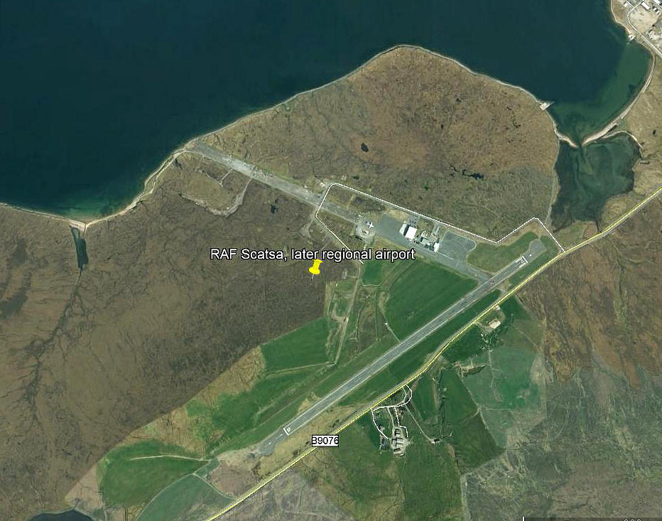
Note: This picture (2008) was obtained from Google Earth ©
Military user: WW2: RAF Coastal Command 18 Group
Operated by: 1980s: Highlands & Islands Airports Ltd
1990: Airwork Ltd (On behalf of B.P Ltd)
2000: Serco Aviation Services on behalf of Bristow Helicopters
Location: Sullom Voe is to the N and Garth Voe to the NE, (these are areas of water), N & W of B9076, roughly 18nm N of Lerwick
Period of operation: Military: 1940 to 1946 Civil: 1978 to -
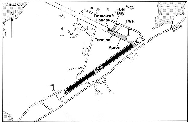
Note: This map is reproduced with the kind permission of Pooleys Flight Equipment Ltd. Copyright Robert Pooley 2014.
Runways: WW2: 07/25 1381x46 hard 13/31 1280x46 hard
1990/2000: 06/24 960x28 hard
2001: 06/24 1360x31 hard
NOTES: SULLOM VOE flying boat base was the ‘Parent’ for SCATSA in WW2 and it would seem likely the two stations were co-located but I haven’t found solid proof of this to date. One thing does seem pretty certain, and this is that being stationed here was one of those postings airmen and other ranks probably dreaded. At the end of 1944 just 362 RAF personnel were on station and not a WAAF in sight. One can only hope the sheep were attractive, I suppose!
In 1985 it was also used for private flying according to one reliable source.
In a flight guide published in 2000 a warning is given that there is “an area of bad ground within the south side of the strip near Rwy 06 threshold”. Having flown into over 250 locations around the world, I have no idea what “bad ground” is, or what pilots are expected to do about it. In October 2018 I was kindly contacted by Chris Eley of the 255 Squadron Association who points out the requirement at licensed airfields to place 'Bad Ground' marker boards on areas where, for example, an aircraft is liable to get bogged down - leading to a reportable incident.
There is also another term I am not familiar with, again with a warning. Apparently the taxiway south of the main apron has a “semi-width” of only 6.6 metres. What is a taxiway “semi-width?” I suppose this means only part of the existing taxiway is useable but generally speaking the 'lane' width within which you are expected to taxy within, is defined by painted lines.
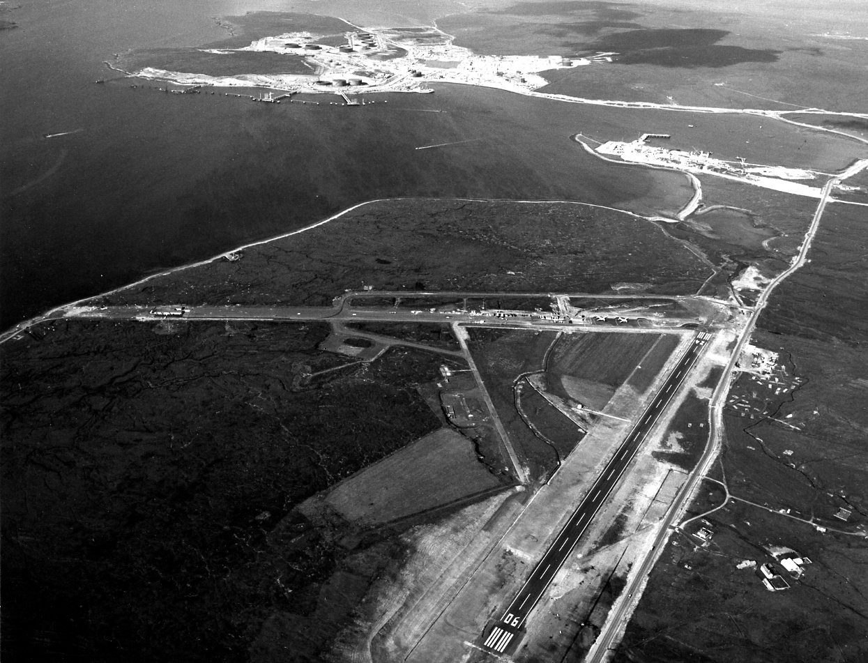
The caption for the top picture is well worth stating: "Sullom Voe Terminal Project, Shetland - Scatsta Airfield ready for operations to commence. Dan Air HS748 aircraft positioned ready for next day's first operational flights. General view of airfield looking north, with oil terminal in background." The date was the 23rd July 1978. Note the term airfield - not airport. But, is SCATSTA the only oil terminal to have its own dedicated airport? Another point of interest is that the Avro (HS) 748 was an exceptional design, quite capable of operating into airfields with runways a tad short of 1000 metres, and sold quite well in the international market. But, did it have the support it deserved, even at government level? Probably not.
Some forty years ago I had the opportunity to be a passenger in this type, on three flights in Thailand, but had no idea then, about just how good this aeroplane really was.
Phill Reid
This comment was written on: 2019-05-23 18:59:263 budgies took off from Glasgow ,weather bad at scatsta FOG,firs landed ok ,we where next said to the guy next to me we are going to fast used the full runway and a bit more 3 budgie turned around and went to Aberdeen I believe,that was flying
We'd love to hear from you, so please scroll down to leave a comment!
Leave a comment ...
Copyright (c) UK Airfield Guide
